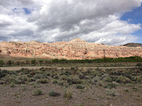
It is 76mi (122km) from Lander (5;358 feet elevation
= 1’633m) to Dubois (elevation 6’939 feet = 2’115 m). If it was a quick and
easy ride this morning, and it was, at an average speed of 12.5mph (20.1 km/h,
that was only because there was little or no wind. Against a strong headwind,
it would have been a nightmare ride.
Most of the way, I was following the Wind
River upstream. The river did not get its name for nothing. The wind blows
through this valley constantly. In winter, it prevents the snow from lying and
keeps the shrubs and grasses exposed as a food source for wildlife. The world's
largest herd of Rocky Mountain bighorn sheep overwinters here.
 I entered the
Wind River Indian Reservation soon after leaving Lander and straight away came
to a casino. Many Native Americn communities operate a casino as their tribal
sovereignty limits the ability of the state to forbid it.
I cycled through Fort
Washakie, noting the sign to the grave of Sacajawea, too far
off route to contemplate a visit. Sacajawea was a Shoshone woman married to one of the members of the Lewis & Clark
expedition. She accompanied them and performed valuable services as interpreter
and guide.
A view miles before Crowheart I met David & Chrissy from Oregon. They are eastbounders and riding across with a support vehicle. It is always a good opportunity to stop and chat and share some experiences and giving recommendations. I stopped at Crowheart to buy and consume a coffee, a banana and a
blueberry muffin.
Tomorrow I am going to climb another major pass (Togwotee Pass; elevation 9’658 feet = 2’944m), the highest on the
route apart from Hoosier Pass, which I went over a view days ago. I will stay overnight at Colter Bay Village (Grand Teton National Park) where I have booked a single cabin. The day after tomorrow I will enter the Yellowstone National Park Resort, which also means visiting my eight state Montana.


No comments:
Post a Comment